The abandoned old coal mines not far from Cagliari on the south-west coast have a very special charm. Beyond their historic value, for which they undoubtedly deserve to be visited, they also have value from a purely landscape point of view, which makes them an unusual and irresistible tourist destination. The slow wear and tear caused by the weather and by time, combined with the resurgence of native vegetation in places where it was eradicated, transformed what was left behind by previous extractive mining processes into something that is not yet a proper natural environment and that is no longer just an old ruin: it is instead a particular type of landscape, which every time seems to draw from chapters of its most recent history. It is worth getting into the car towards the south-west coast of Sardinia and more specifically the so-called Costa Verde where industrial archeology and spectacular land and marine environments coexist in a truly impressive way.
– From Nebida to Cala Domestica –
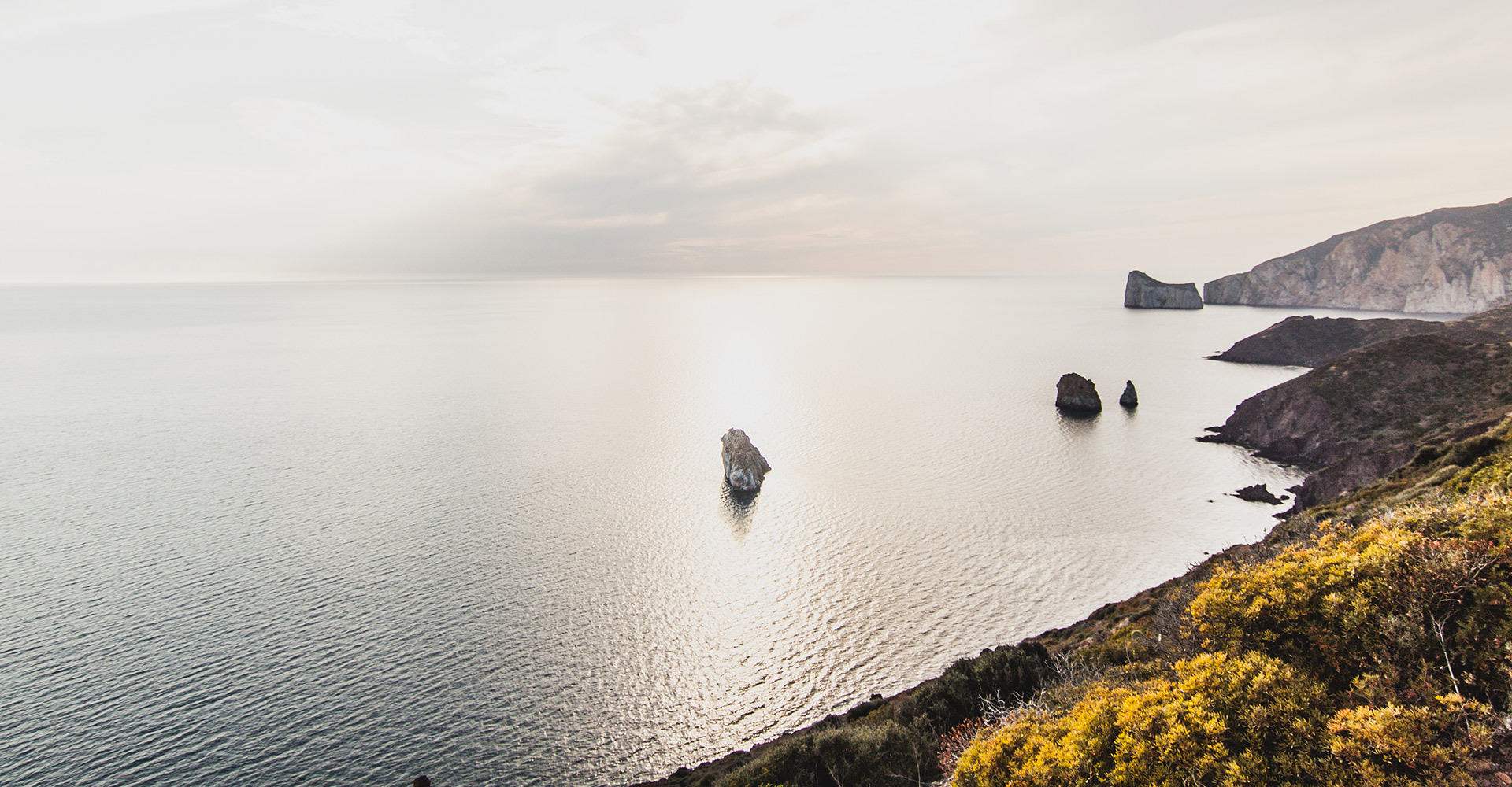
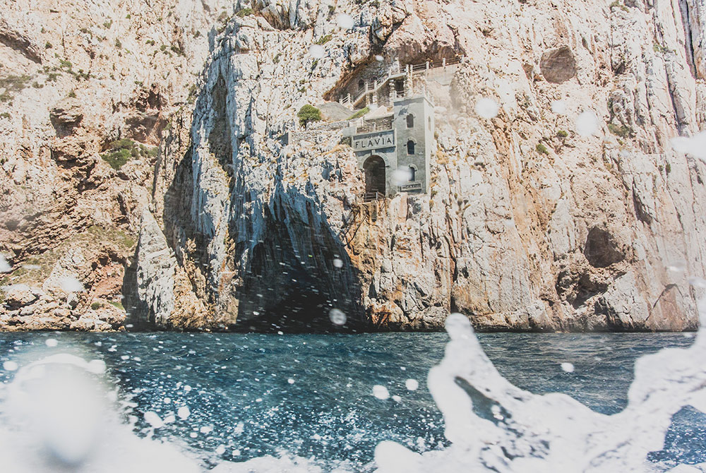
The stretch of rocky and high coastline that extends from the cliffs of Nebida to the narrow inlet of Cala Domestica is the most interesting by far. It is easy reachable after the fantastic Fontanamare beach, which is ideal for a refreshing dip in the sea after your journey from Cagliari. Along the road that leads to Masua, an ex small mining town, punctuated by inaccessible cliffs, deep inlets and small beaches, is the spectacular Pan di Zucchero, a very imposing limestone islet edged by vertiginous cliffs. After travelling alongside the old mining plants, the tunnels of Porto Flavia, a jewel of Sardinian mining archeology and the main attraction of the Parco Geominerario della Sardinia, which is a destination of great interest for the architectural merit of some of its structures and as a testimony of a not so distant history as well as a perfect example of extraordinary panoramic views of the sea.
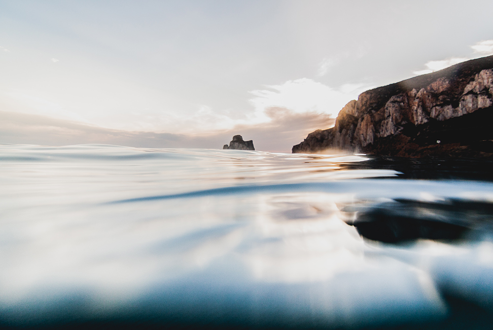
Along the road that leads to Porto Flavia, there is the start of a beautiful panoramic path that runs along the coast and guarantees truly evocative views. The route is quite long: it is sufficient, however, to cover just the initial stretch to get an idea of the beauty of the surrounding landscape. Afterwards, back in the car and on the Strada Provinciale in direction of the end of the panoramic path in order to reach Cala Domestica, the most beautiful small bay in this entire coastal stretch. Set in an inlet dug deeply in the coastline, dominated by an old tower and closed in by high cliffs, the beach shows a striking contrast between the golden sand dunes and the deep blue of the sea. A short tunnel, a testimony of the mining past of the area, leads to the Caletta: a small jewel of Sardinian natural landscape.
– From Buggerru to Ingurtosu and Piscinas –
With the ruins of the laveria Malfidano, laverias being old industrial plants where coal was enriched and washed, that dominate the small port, the small town of Buggerru represents the next stop on the itinerary. Around here, every single object has a story to tell: behind every little wall, in the shadow of every structure hides a chapter of a long history. From Buggerru, going north, you will find the beach and the village of Portixeddu. Behind the beach, the hills covered by dense maquis shrubs descend into a jagged line of rocks to the coastline creating a dreamlike landscape.
Inland, easily reachable from the main road that leads to Flumini Maggiore, the caves of Su Mannau, well worth visiting in the company of local speleologists, and the Tempio di Antas, a sacred building of Nuragic origin, rebuilt in Punic and Roman times. It is still possible to experience the sacredness of these ancient places of worship.
The Capo Pecora cliffs are also easily reachable; we suggest to venture along the coastal path that runs between huge granite rocks and steep descents into the sea. After a two or three hours walk , the wild beach of Scivu, which is also easily reachable by car by following the Strada Provinciale first and then the Strada Comunale towards Scivu, is most definitely worth visiting.
From the Strada Statale 126, turn on the Strada Provinciale 66 to reach the old mining village of Ingurtosu. Now abandoned, the village spreads at the end of a long valley that goes towards the sand dunes in Piscinas. Once the centre of the eponymous mine and of the nearby Gennamari mine, Ingurtosu preserves many of the characteristic architectures of the mining settlements of yesteryear. In the nearby Naracauli ex industrial site, you can see what remains of the imposing laveria Brassey. Travelling towards the beach of Piscinas, the old mine depots. From here onwards, the immense ocher dunes, among the most impressive in Europe, dominate the view and encircle the very long beach for a few kilometres, crowning it with juniper and mastic.
– Carbonia: the Museo del Carbone museum and the Monte Sirai ruins –
On the way back to Cagliari, you must stop in Carbonia. Built in the space of just two years by Benito Mussolini, who inaugurated it in 1938, the town shows at first glance the urban layout and the architectures of the cities and towns built during the 1920’s by the Fascist regime. A walk in Piazza Roma, the epicentre around which the city was built, makes it possible to recognise Carbonia most important public buildings: a set of different buildings in different styles, made homogeneous by the widespread use of rustic cladding in trachyte blocks. After a coffee, we suggest a visit to the Museo del Carbone museum, which is focused on the history of the local coal mining industry. Located in the old lamp rooms, in the underground gallery and the winch room of the Serbariu mining site, the museum is undoubtedly where the history of the city and its inhabitants is told with most clarity. In particular, the old lamp room, where the machinery to recharge the Edison lamps were once located, nowadays houses a permanent display of lamps, work tools, tools and images relating to the old world of coal mining.
The most important archaeological site near Carbonia is Monte Sirai, easily reachable by turning at km 17 of the Strada Provinciale: the road climbs up the side of the mountain to reach the plateau that preserves the ruins of the ancient town and dominates the view of the vast plain, up to the coast and to the islands of San Pietro and Sant’Antioco. Divided into the three large areas, i.e. the residential section, the tophet or open air sanctuary, and the necropolis, the site offers the opportunity to discover the Phoenician and Punic civilisations without the usual presence of buildings built at later stages. As a matter of fact, the original urban layout has remained intact since the town was abandoned around 100 BC. The strategically important small town was built in direct contact with the numerous Nuragic settlements nearby, among which the one occupied by the Sirai Nuraghe, built a little further south and easily accessible, is probably the most important. The megalithic monument consists of a central tholos, a circular construction with a dome, surrounded by a bastion with quatrefoiled decorative patterns, whose towers are oriented according to the four cardinal points.
After the emotions caused by discovering and experiencing Sardinian civilisations of the past, we suggest to go back to the Strada Statale 195, also known as Sulcitana, towards the pleasantly surprising Teulada and Domus de Maria small towns in order to get to Chia and its truly wonderful beaches.

Three walks along the shore – three great small trips to discover the colours and fascination of a truly unique sea.

The coasts of Sardinia seen from an elegant schooner. Fresh breezes and clear seas under the shade of the spread sails.
 BACK
BACK